Fire Season Ends in Klamath & Lake Counties

Fire Season Ends in Klamath & Lake Counties

Klamath Falls, Ore. - Klamath and Lake Counties’ 2017 Fire Season is officially ending Friday, October 20, 2017 at 12:01 am. “Fire Season” for the area has been in effect since June 5th.   During the 2017 season, the Klamath-Lake District has documented 129 fires that burned approximately 1,937 acres on ODF protected lands. For the ODF Klamath-Lake District, just about half of the total number of fire starts came from numerous summer lightning storm events. The other half were human caused ignitions.   

Read More

Update: OR Agencies Assisting California Wildfires

Update: OR Agencies Assisting California Wildfires

As firefighters slowly get the upper hand and weather improves somewhat in northern
California, two Oregon Strike Teams (Marion County and Jackson Josephine counties) are being demobilized today and will head back to their home stations over the next 24 hours.

More Oregon Strike Team demobilizations are in the planning stages if conditions continue to stabilize.

Read More

Prescribed Fire Operations Planned in Chemult Area

Prescribed Fire Operations Planned in Chemult Area

CHEMULT, Ore. – The Fremont-Winema National Forest Chemult Ranger District plans to begin prescribed burning October 17 through November 1, conditions permitting.

Approximately 500 acres of prescribed burning is planned for the Chemult Townsite Project area, located adjacent to the town of Chemult on Highway 97 and 400 acres in the Jack Unit area, located 13 miles east of Chemult, near Tea Table Mountain. An additional 700 acres are scheduled to be burned within the Cub Unit area, which is 25 miles southwest of Chemult, near Lookout Butte south of Highway 138.

Read More

ODF Sends Fire Engine Crews to Help with Northern California Wildfires

ODF Sends Fire Engine Crews to Help with Northern California Wildfires

MEDFORD, Ore. -- Four Oregon Department of Forestry fire engines and their two-person crews arrived in Northern California yesterday to help with wildfires that have been ravaging parts of that state. ODF's Southwest and Klamath-Lake districts bordering California sent the crews as part of a long-standing mutual fire aid agreement between U.S. states. Two of the engines came from Grants Pass, one from Klamath Falls and one from Medford. A ninth ODF employee also went from Medford in a support role. Because of more than a dozen wind-driven wildfires, California's governor has declared a fire emergency in three counties - Napa, Sonoma and Yuba. These fast-moving fires have caused fatalities, burned down homes and businesses, caused hurried evacuations and fully engaged local and state firefighting resources. The ODF teams will be put to use where the Northern California incident command deems they are needed most.
 

Read More

Fall Prescribed Fire Season starting in South Central Oregon

Fall Prescribed Fire Season starting in South Central Oregon

LAKEVIEW, Ore. – Over the next several weeks, communities in south central Oregon may see a different type of smoke column rising above the tree tops; a column that is the sign of the return of prescribed fire to the land.

Fire managers at the South Central Oregon Fire Management Partnership (SCOFMP) will be taking the opportunity to begin prescribed burning beginning the first week of October as weather conditions permit.

Area residents and visitors may notice smoke on public lands in various areas during the next few months as part of the continued commitment to protect communities and natural resources from wildfires.

Read More

Wildfire Update: High Cascades Complex [Video]

*** VIDEO - Chipping Efforts on the High Cascades Complex East Zone - AUDIO CAUTION - No audio with the exception of a loud chainsaw. (Inciweb) ***

Summary: Crews continued chipping away on repair efforts; increasing repair completion to 43 percent. Aerial operations assisted firefighters by shuttling crews and supplies into difficult to reach areas. While a warm and dry weather trend continued, high clouds prevented major temperature increases. Lingering snow remained a hurdle to repair operations but continued to slow remaining fire activity. Fire perimeters have little potential for movement. Grading operations are progressing smoothly as heavy equipment operator continue to overhaul roads impacted by operations.

North Pelican (27% repair complete): Crews cleaned the trailhead at the end of Cold Springs Road leading into the wilderness. Chipping is expected to continue on the North Pelican for the next several days to remove excess slash along the roads. In addition to hand work, three excavators will repair access roads surrounding the fire.

Blanket Creek Fire (45% repair complete): Firefighters finished much of the rehab work on the southeastern edge of the fire perimeter. Heavy equipment operators will continue scouting the dozer lines closer to Mazama Village to develop a timeline for repairs. The protective material surrounding the Honeymoon Cabin is expected to be removed today.

Spruce Lake Fire (62% repair complete): Air operations provided major assistance to crews on the Spruce Lake Fire by transporting 4,350 pounds of cargo to the Hotshot Crew repairing handline. A crew working in the backcountry is expected to reach the West Rim Road tomorrow.

Closures: Fire closures remain on public lands within some hunting units. Check trail, road, and area closures on InciWeb, park and forest websites. West Rim Drive in Crater Lake National Park remains closed for scheduled maintenance and repaving through Friday at 4 p.m.

Weather: The warming and drying trend should continue through Thursday when highs will reach the mid-70s and daytime relative humidity will drop to 30% or less. Long-range forecasts suggest a renewed wetter pattern by early next week.

Traffic: Expect possible delays on Highway 230 between Union Creek and the junction with Highway 138 due to road construction. In Crater Lake National Park, heavy construction traffic may bring delays near North Junction.

Wildfire Update: High Cascades Complex

East Zone Update

Southern Oregon Fire Map (Inciweb)

Southern Oregon Fire Map (Inciweb)

*** ATTN Hunters - Check fire restrictions before heading out, some units still have restrictions. East Zone containment at 40% ***

Fire officials report the High Cascades Complex East Zone at 40% contained. Improving weather conditions and lack of fire growth is allowing firefighters to focus their efforts on suppression repair. Excavators and other heavy equipment will be shifted between fires to reflect operational needs over the next several days. Please be cognizant of heavy equipment traveling the roads in fire areas. As of Monday morning, approximately 32% of the total suppression repair work is complete.

Excavators assisted crews on the North Pelican Fire (repair work 17% complete) repair bulldozer line. Handcrews completed culvert repairs on NF Road 350 and grading occurred on NF Road 3519. On the Blanket Creek Fire (repair work is 21% complete), chipping continued on the east flank of the burned area. Crews scouted and began repairing handline in backcountry areas of Crater Lake National Park. Crews on the Spruce Lake Fire (repair work is 52% complete) completed rehab from the forest-park boundary to the Pacific Crest Trail. Crews are making good progress at Spruce Lake, but are encountering snow as they move into higher elevations in the wilderness and national park.

Closures: Weather conditions and anticipated fire behavior allowed the Fremont-Winema National Forest to modify its fire closure areas on both the Blanket Creek and North Pelican Fires. These alterations may impact backcountry recreationalists, hunters, and OHV users. Know before you go! Check trail, road, and area closures and conditions on InciWeb, park and forest websites. West Rim Drive in Crater Lake National Park remains closed for scheduled maintenance and repaving through Friday afternoon at 4 pm.

Hunting: The Oregon Department of Fish and Wildlife does not close hunting seasons due to fire danger. However, fire closures still remain on public lands within some hunting units. Hunters are urged to check closures before heading out.

Weather: A weak disturbance is expected to move through the region on Monday. High level clouds may reduce temperatures a few degrees, but a warming and drying trend is expected through Thursday.

The Rim Visitor Center, Annie Creek Restaurant and Gift Shop, and the Mazama Campground cabins are closed for the season. Expect possible delays on Highway 230 between Union Creek and the junction with Highway 138 due to road construction.

Press release from High Cascades Complex PIO (Inciweb)

Wildfire Update: High Cascades Complex

East Zone Update

*** Firefighers continue to work in rain and snow. ***

All three fires received wetting rains Monday night. Although some heat remains in dead and down surface fuels and litter, rains, cooler temperatures and high humidity greatly assisted firefighting efforts. As fire progression slows, crews will develop plans to rehabilitate hand and dozer lines used in suppression operations. The Incident Command Post was busy today constructing large tents with heaters to provide returning crews a warm place to dry out after a long day on the fire line. Inclement weather impeded aerial observations so no new acreage is available.

Spruce Lake Fire: (15,826 acres and 22% contained) Little fire growth is expected but active monitoring will continue.

Blanket Creek Fire: (33,322 acres and 28% contained) Crews conducted a minor backfire operation to button up a hot spot near constructed line along the southwest edge. Crews continue to prep between forest road 800 and 600, removing hazard trees to prepare for possible dozer work. Structure protection continued at Mazama Village.

North Pelican Fire: (3,589 acres and 73% contained) Heavy equipment and crews continued improving contingency lines on the north and southwest edges. Crews started to evaluate possible suppression repair opportunities. Weather permitting, crews will begin some suppression repair today along the southern boundary.

Weather: A robust rain event is expected the next few days. Total rainfall will range from one to almost two inches. Snow of up to eight inches is anticipated at elevations above 6000 feet. A warming and drying trend begins Thursday as high pressure builds over the Pacific Northwest.

Closures: A number of area road and trail closures are in place within Crater Lake National Park, Rogue River-Siskiyou, Umpqua, and Fremont-Winema National Forests. For specific closure information, visit https://inciweb.nwcg.gov/incident/5503. The North Entrance Road to Crater Lake National Park is open. The West Rim Drive is closed until Friday at 4:00 p.m. due to construction. All concession facilities and services remain open for visitors to the Park. Motorists and visitors to the area also need to be aware of delays on Highway 230 between Union Creek and the junction with Highway 138 due to road construction.

A Level 1 Evacuation Notification remains in effect for Mazama Village in Crater Lake National Park. Level 1 is the first step in the “Be Ready, Be Set, Go!” system. For more information about evacuation levels and procedures, go to http://tinyurl.com/BeReady-BeSet-Go.

Incident Summary Quick Facts
Fire Locations: Rogue River-Siskiyou National Forest; Fremont-Winema National Forest-Klamath Ranger District; Crater Lake National Park; 
Approximate Acreage: 52,737 acres (East Zone Only)
Containment: 39% (East Zone Only)

Start Date: 
North Pelican – 08.10.2017
Spruce Lake – 07.29.2017
Blanket Creek – 07.26.2017

Cause: Lightning
Incident Commander: Tim Roide, Great Basin Incident Management Team #4
Total Personnel: 339

Wildfire Update - High Cascades Complex, East Zone

**** Cooler weather helping firefighting efforts. Southwest IMT 3 to transition to Great Basin IMT 4 Today. ****

The North Entrance Road to Crater Lake National Park is open and will remain open. West Rim Drive will be open until 9:00 pm tonight. All concession facilities and services remain open for visitors to the Park. Motorists and visitors to the area also need to be aware of delays on Highway 230 between Union Creek and the junction with Highway 138 due to road construction.

The Southwest Area Incident Management Team #3 will transition with the Great Basin Incident Management Team #4 today. The High Cascades Complex East Zone includes the Spruce Lake, Blanket Creek, and North Pelican fires.

A dry cold front has moved into the area bringing winds out of the west, southwest that will have gusts to about 25 miles per hour by this afternoon.

Spruce Lake Fire (15,826 acres and 22% contained) Aerial observations were done yesterday. No movement was detected and no growth is expected with the cooler and wetter weather moving into the fire area.

Blanket Creek Fire (33,322 acres and 21% contained) Crews continue to hold and strengthen containment lines to the north and east. There was fire activity along the southwest side as it moved through the old Middle Fork burn.

North Pelican (3,589 acres and 73% contained) Heavy equipment and crews continued construction of contingency lines. Fire behavior today was quiet with not much movement.

A Level 1 Evacuation Notification remains in effect for Mazama Village in Crater Lake National Park. Level 1 is the first step in the “Be Ready, Be Set, Go!” system. For more information about evacuation levels and procedures, go to
http://tinyurl.com/BeReady-BeSet-Go.

Smoke Outlook: A full smoke forecast can be viewed at: https://inciweb.nwcg.gov/incident/5503. To see visibility at
Crater Lake National Park, check out the webcams at https://www.nps.gov/crla/learn/photosmultimedia/webcams.htm.

Closure Information: As a result of the fires in the High Cascades Complex, a number of area road and trail closures are in place within Crater Lake National Park, Rogue River-Siskiyou, Umpqua, and Fremont-Winema National Forests. More road and trail closures may go into effect as the fires progress. For specific closure information, visit https://
inciweb.nwcg.gov/incident/5503.

Location: High Cascades Ranger District, Rogue River-Siskiyou National Forest, Klamath Ranger District, Fremont-Winema National Forest, Crater Lake National Park

Start Date: 
North Pelican August 10, 2017, 
Spruce Lake July 29, 2017, 
Blanket Creek July 26, 2017

Cause: Lightning
Size: 52,737 Acres
Percent Contained: 16% (% encompasses total of both East and West zone of the complex
excluding Spruce Lake fire from the Complex)
Vegetation: timber, brush, heavy logging slash
Resources Assigned: 326
Incident Commander: Steve Millert/Dave Gesser with the Southwest Area Type 2 Incident Management Team 3

Fire Danger Drops to High

**** Jackson and Josephine Counties ****

21743083_1718750258166329_7747824020716050735_n.jpg

A combination of higher relative humidities and cooler temperatures across southwest Oregon have made it possible to ease-off on some fire prevention regulations. The fire danger level on Oregon Department of Forestry-protected lands in Jackson and Josephine counties will be lowered to “high” (yellow) tomorrow, September 15, 2017 at 12:01 a.m. The Industrial Fire Precaution Level will remain at a level 3 (three).

These regulations affect 1.8 million acres of state, private, county, city and Bureau of Land Management lands protected by ODF Southwest Oregon District.

Restrictions on the public use of chain saws, brush cutters and other power-driven or spark-emitting machinery are being slightly relaxed, allowing the use of equipment until 10:00 a.m. and after 8 p.m. Today will be the last day power-driven and/or spark-emitting machinery is completely prohibited.

Other fire prevention regulations which will remain in effect, include:

• No debris burning, including piles and debris burned in burn barrels.

• No fireworks on forestlands.

• Exploding targets and tracer ammunition, or any bullet with a pyrotechnic charge in its base, are prohibited.

• Campfires are allowed only in designated campgrounds. Portable stoves using liquefied or bottled fuels may be used in other locations.

• Motorized vehicles are allowed only on improved roads; one shovel and one gallon of water, or one 2.5 pound or larger fire extinguisher, is required while traveling.

• Smoking while traveling will only be allowed in enclosed vehicles on improved roads, in boats on the water and other specifically designated locations.

• Chain saws may not be used between 10:00 a.m. and 8:00 p.m. during high fire danger. During hours outside of this time frame, chain saws may be used but require that the operator have one shovel and one 8-oz or larger fire extinguisher at the work site. A fire watch is also required for one hour after each chainsaw use.

• Cutting, grinding, and welding of metal is not allowed between 10:00 a.m. and 8:00 p.m. during high fire danger. These activities will be allowed during hours outside of this time frame only if the work site is cleared of potentially flammable vegetation and other materials, and a water supply is at the job site.

• The mowing of dead or dried grass with power-driven equipment is not allowed between 10:00 a.m. and 8:00 p.m. during high fire danger. This restriction does not include mowing of green lawns, or equipment used for the commercial culture and harvest of agricultural crops.

• Any other spark-emitting internal combustion engine-use not specifically mentioned is not allowed between 10:00 a.m. and 8:00 p.m. during high fire danger. Use of any spark-emitting internal combustion engine is allowed outside of this time frame only if the work site is cleared of potentially flammable vegetation and other materials, and a water supply is at the job site.

• Any electric fence controllers must be approved by a nationally recognized testing laboratory, such as Underwriters Laboratories Inc., or be certified by the Department of Consumer and Business Services, and be installed and used in compliance with the fence controller’s instructions for fire safe operation.

For more information about the Oregon Department of Forestry’s fire season public restrictions, please call or visit the Southwest Oregon District unit office nearest to you:

• Medford Unit, 5286 Table Rock Rd., Central Point. (541) 664-3328
• Grants Pass Unit, 5375 Monument Dr., Grants Pass. (541) 474-3152

Fire season information is also available online at our Facebook page: @ODFSouthwest and our website: www.swofire.com.

Press Release from ODF Southwest Oregon District

Wildfire Update - High Cascades Complex, East Zone

The High Cascades Complex East Zone includes the Spruce Lake, Blanket Creek, and North Pelican fires. A cold front is moving into the area today with cooler conditions and gusty winds. The cooler temperatures will remain through the weekend with low temperatures down to freezing.

Spruce Lake Fire (15,660 acres and 27% contained) The fire showed minimal fire behavior as crews continue to strengthen the fire lines. Chipping operation will be completed today.

Blanket Creek Fire (31,470 acres and 11% contained) Crews continue to hold and strengthen containment lines to the north and east to hold it off the highway corridor. The structure protection team continues to assess the values at risk in Mazama Village in Crater Lake National Park and are in the process of developing a structure protection plan.

North Pelican (3,427 acres and 25% contained) Crews continue to work to the north building containment lines on the fires perimeter pushing the fire into the wilderness.

A Level 1 Evacuation Notification remains in effect for Mazama Village in Crater Lake National Park. Level 1 is the first step in the “Be Ready, Be Set, Go!” system. For more information about evacuation levels and procedures, go to http://tinyurl.com/BeReady-BeSet-Go.

Closure Information: As a result of the fires in the High Cascades Complex, a number of area road and trail closures are in place within Crater Lake National Park, Rogue-River Siskiyou, Umpqua, and Fremont-Winema National Forests. More road and trail closures may go into effect as the fires progress. For specific closure information, visit https://inciweb.nwcg.gov/incident/5503.

The North Entrance Road to Crater Lake National Park remain closed. West Rim Drive will reopen on Friday at 4:00 pm. All concession facilities and services remains open for visitors to the Park. Motorists and visitors to the area also need to be aware of delays on Hwy 230 between Union Creek and the junction with Highway 138 due to road construction.

Smoke Outlook: A full smoke forecast can be viewed at: https://inciweb.nwcg.gov/incident/5503. To see visibility at Crater Lake National Park, check out the webcams at https://www.nps.gov/crla/learn/photosmultimedia/webcams.htm.

Location: High Cascades Ranger District, Rogue River-Siskiyou National Forest, Klamath Ranger District, Fremont-Winema National Forest, Crater Lake National Park

Start Date: 
North Pelican August 10, 2017, 
Spruce Lake July 29, 2017, 
Blanket Creek July 26, 2017

Cause: Lightning
Size: 50,557 Acres
Percent Contained: 16% (% encompasses total of both East and West zone of the complex excluding Spruce Lake fire from the Complex)
Vegetation: timber, brush, heavy logging slash Resources Assigned: 932 personnel (Personnel for the entire complex)
Incident Commander: Steve Millert/Dave Gesser with the Southwest Area Type 2 Incident Management Team 3

South Central Oregon Fire Management Partnership - SCOFMP
Crater Lake National Park
U.S. Forest Service - Fremont-Winema National Forest

WILDFIRE UPDATE - High Cascades Complex

East Zone Update

The High Cascades Complex East Zone includes the Spruce Lake, Blanket Creek, and North Pelican fires. Temperatures will be a few degrees cooler and humidity will be a little bit higher than yesterday. Winds will be out of the west/northwest, with a chance of isolated thunderstorms mainly east of the fires.

Active fire Sept. 11 on the Pup Fire near Hershberger Creek. Photo by Josef Porter (Inciweb)

Active fire Sept. 11 on the Pup Fire near Hershberger Creek. Photo by Josef Porter (Inciweb)

Spruce Lake Fire (14,671 acres and 21% contained) Firefighters are working on a structure plan for the values at risk in Crater Lake National Park. Crews are in the last days of finishing up the chipping operations along the North Entrance Road to prevent the fire spread to the east of the road.

Blanket Creek Fire (39,730 acres and 17% contained) Crews continue to strengthen and monitor the containment lines to the north and east to hold it off the highway corridor.

North Pelican (3,427 acres and 40% contained) Crews worked to contain a 15-acre spot fire and continue to work the north edge of the fire in rugged terrain with low flames lengths and moderate fire behavior. Acreage changed due to more accurate mapping.

A Level 1 Evacuation Notification remains in effect for Mazama Village in Crater Lake National Park. Level 1 is the first step in the “Be Ready, Be Set, Go!” system. For more information about evacuation levels and procedures, go to http://tinyurl.com/BeReady-BeSet-Go.

Smoke Outlook: 
A full smoke forecast can be viewed at: https://inciweb.nwcg.gov/incident/5503. To see visibility at Crater Lake National Park, check out the webcams at https://www.nps.gov/crla/learn/photosmultimedia/webcams.htm.

For further information please visit the following links:
Inciweb: https://inciweb.nwcg.gov/incident/55 03
Facebook: https://www.facebook.com/R6RRSNF/https://www.facebook.com/SCOFMPFIREINFO/
Twitter: https://twitter.com/RRSNF
Joint Information Center: https://swojic.blogspot.com/
Oregon Smoke Blog: http://oregonsmoke.blogspot.com/

Location: High Cascades Ranger District, Rogue River-Siskiyou National Forest, Klamath Ranger District, Fremont-Winema National Forest, Crater Lake National Park

Start Date: 
North Pelican August 10, 2017, 
Spruce Lake July 29, 2017, 
Blanket Creek July 26, 2017
Cause: Lightning
Size: 98,379 Acres
Percent Contained: 28% (% encompasses total of both East and West zone of the complex) 
Vegetation: timber, brush, heavy logging slash Resources Assigned: 689 personnel (Personnel for the entire complex)
Incident Commander: Steve Millert/Dave Gesser with the Southwest Area Type 2 Incident Management Team 3

Closure Information: 
As a result of the fires in the High Cascades Complex, a number of area road and trail closures are in place within Crater Lake National Park, Rogue-River Siskiyou, Umpqua, and Fremont-Winema National Forests. More road and trail closures may go into effect as the fires progress. For specific closure information, visit https://inciweb.nwcg.gov/incident/5503.

The North Entrance Road to Crater Lake National Park remains closed. West Rim Drive will reopen on Friday at 4:00 pm. All concession facilities and services remain open for visitors to the Park. Motorists and visitors to the area also need to be aware of delays on Hwy 230 between Union Creek and the junction with Highway 138 due to road construction.

Forests Bridge Gap to Reach Wildfire

As a wildfire rages across a forest, fire engines and heavy equipment travel swiftly along forest roads to get to the fire line. They arrive at the main bridge they need to cross, only to find it has burned and is impassible. This is not part of a storyline in a movie, it was reality for firefighters assigned to the Parker 2 Fire on the Modoc National Forest in August 2017.

The first firefighters to cross the newly placed bridge. (USDA photo by Chris Bielecki)

The first firefighters to cross the newly placed bridge. (USDA photo by Chris Bielecki)

When firefighters discovered the burned bridge in the Warner Mountains, they reported it to the Incident Management Team (IMT). An IMT is called upon to help a forest manage a fire or other emergency incident that grows too large for them to manage by themselves. Heather McRae, working as the Operations Section Chief Trainee on the IMT, remembered that there was an unused bridge being stored at the Ashe Creek Guard Station on the nearby Shasta-Trinity National Forest. When she isn’t working on fires, Heather works as the Prescribed Fire and Fuels Specialist on the STNF. Heather quickly relayed to the MNF about the possible replacement bridge.

Upon hearing about the unused bridge, MNF Roads Engineer, Alvin Sarmiento, coordinated with STNF Engineer, Virginia Jones, to investigate if the bridge would fit the span needed. Shortly thereafter, MNF was sending their construction and maintenance crew over to load the bridge and transport it to the Warner Mountains.

Understanding the urgent need for the bridge to be in place to help firefighters battle the Parker 2 Fire, the IMT prioritized the resources needed to move it into place. From the time construction actually began, to the time the bridge was crossed by the first firefighters, only five days had passed.

“This was an incredible team effort. We tapped into the power of the IMT ordering and buying team, supply specialists and ground support for picking up and delivering parts, the operations section for providing invaluable contract equipment and operators, and our local road crew,” said Chris Bielecki, Forest Engineer on the MNF. “And it still amazes me that the bridge was available in the first place, and that it was the right size. This experience was definitely a career highlight for me.”

While sharing resources among national forests isn’t something new to the Forest Service, the sharing and placement of physical structures like this bridge in the middle of an emergency is unique.

“When it comes to fighting fire or responding to other emergencies, if we can help another forest in their time of need, we will do it every time,” said Dave Myers, Forest Supervisor for the STNF.

The Parker 2 Fire was last reported at 7,697 acres and thanks to the nearly installed bridge has been fully contained.

USFS Article By Josef A. Orosz III, Public Affairs Specialist, Shasta-Trinity National Forest and Chris Bielecki, Forest Engineer, Modoc National Forest

Secretary Zinke Directs Interior Bureaus to Take Aggressive Action to Prevent Wildfire

WASHINGTON – Today, U.S. Secretary of the Interior Ryan Zinke directed all Department of the Interior bureaus, superintendents, and land managers at all levels to adopt more aggressive practices, using the full authority of the Department, to prevent and combat the spread of catastrophic wildfires through robust fuels reduction and pre-suppression techniques.

Image: Orleans Complex Fire (Inciweb)Press Release from US Department of the Interior

Image: Orleans Complex Fire (Inciweb)
Press Release from US Department of the Interior

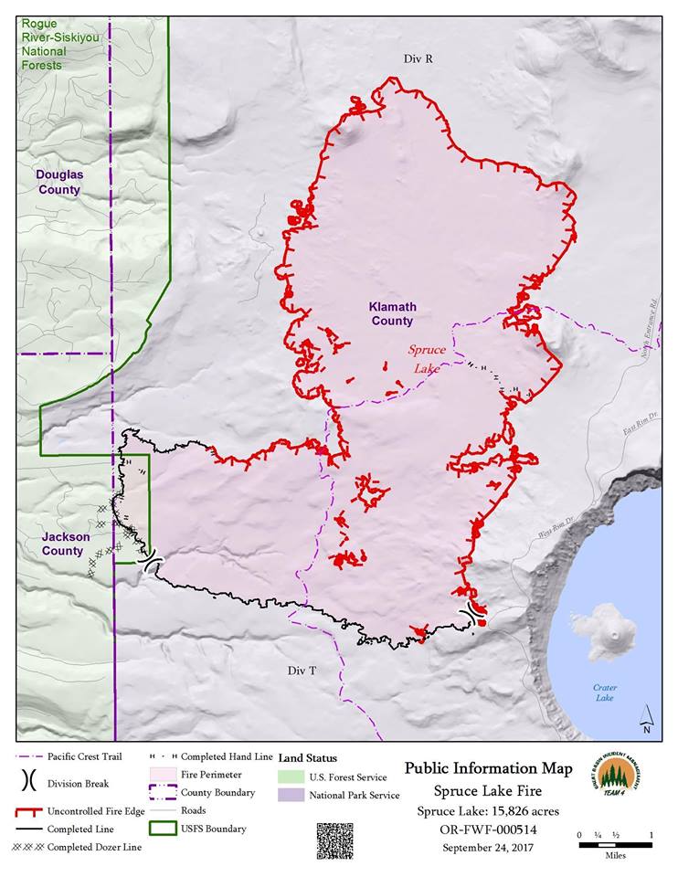
This year-to-date, 47,700 wildfires have burned 8 million acres across the country, with the majority of the devastation in the states of California and Montana. High-profile fires in Yosemite and Glacier National Parks have caught national headlines, however millions of acres of forest and grassland have burned in recent months.

"This Administration will take a serious turn from the past and will proactively work to prevent forest fires through aggressive and scientific fuels reduction management to save lives, homes, and wildlife habitat. It is well settled that the steady accumulation and thickening of vegetation in areas that have historically burned at frequent intervals exacerbates fuel conditions and often leads to larger and higher-intensity fires," said Secretary Zinke. "These fires are more damaging, more costly, and threaten the safety and security of both the public and firefighters. In recent fire reviews, I have heard this described as 'a new normal.' It is unacceptable that we should be satisfied with the status quo. We must be innovative and where new authorities are needed, we will work with our colleagues in Congress to craft management solutions that will benefit our public lands for generations to come."

The Secretary is directing managers and superintendents of units that have burnable vegetation to address the threat of fire in all of their activities, and to use the full range of existing authorities, to reduce fuels.

Bryan Rice, Director of the Office of Wildland Fire, said, "It is critical to fully consider the benefits of fuels reduction in the everyday management activities that we carry out for our public land management objectives, such as clearing along roadsides, around visitor use areas like campgrounds and trails, near employee housing areas, and within administrative site areas subject to wildfire."

The Department has lost historic structures in wildfires like Glacier National Park's historic Sperry Chalet lodge. In an effort to help prevent future losses, the Secretary is also directing increased protection of Interior assets that are in wildfire prone areas, following the Firewise guidance, writing: "If we ask local communities to 'be safer from the start' and meet Firewise standards, we should be the leaders of and the model for 'Firewise-friendly' standards in our planning, development, and maintenance of visitor-service and administrative facilities."

“I welcome Secretary Zinke’s new directive and his attention to the catastrophic fires taking place in many western states,” said Senator Lisa Murkowski, Chairman of the Senate Energy and Natural Resources Committee. “Treating our landscapes mitigates wildfire risk, increases firefighter safety, and makes our forests and rangelands healthy and resilient. We can no longer delay the implementation of this important work.”

House Natural Resources Chairman Rob Bishop said, "We must ensure our land management agencies have the tools and resources they need to protect communities and landscapes from catastrophic wildfire. Over the long term, Congress and the Administration must work together to reverse the sorry state of our federal forests and grasslands. I’m heartened to finally have an Administration that’s focused on actively managing and addressing the on-the-ground conditions that are contributing to our historic wildfire crisis. I hope to build on this by enacting comprehensive legislation to restore the health and resiliency of federal lands.”

"If we don't start managing our forests, the forests are going to start managing us," said Montana Senator Steve Daines. "The fires burning across Montana are a catastrophe, and we need all available resources to combat this threat. I applaud Secretary Zinke’s action to focus resources on attacking wildfires."

“I applaud Secretary Zinke’s effort to thin the threat. If we can reduce the fuel loads in our forests and rangelands we will provide our fire fighters more defensible space to do their jobs," said Idaho Senator James Risch. "We need bold actions like this not just for the hurricanes in the south and east but also to avert the devastation caused by the wildfires in the west.”

“More than 50 million acres in the United States are currently at risk for catastrophic wildfire. That is why we must act to prevent calamitous fires. Management actions taken by Secretary Zinke today will not completely stop the risk, but it is an important step forward in our fight to turn unhealthy, overgrown, and infested forests into thriving, healthy ecosystems," said Congressman Bruce Westerman. "I commend Secretary Zinke for recognizing this emergency situation and taking steps to address prevent further loss of life and property due to these preventable, catastrophic wildfires. I am committed to working with him and my colleagues in Congress to find a permanent solution to this problem that emphasizes active forest management as the first line of defense against catastrophic wildfires.”

With Western Fire season reaching its natural peak in September, the National Multi-Agency Coordinating Group (NMAC) elevated the National Fire Preparedness Level to “5”, the highest level NMAC declares, on August 10, 2017. Above normal major-fire activity continues to be observed across portions of the Pacific Northwest, Northern Rockies, northern Great Basin, and northern California. Fuel moisture levels and fire danger indices in these areas are at near-record to record levels for severity. Drier and warmer than average conditions across the central Great Basin and Southern California are allowing for the fine fuels to become more receptive to fire activity.

===========================
FULL MEMORANDUM

To:

Assistant Secretaries
Heads of Bureaus and Offices
Regional Directors
State Directors
Superintendents
Refuge Managers
District Managers
Field Office Managers

From:

Secretary Ryan Zinke

Subject:

Wildland Fire Directive

In June of this year, Secretary of Agriculture Sonny Perdue and I gave direction on a broad strategy for addressing wildfire by managing our firefighting assets in the most efficient way possible. (2017 Direction to Wildland Fire Leadership Memorandum). As we anticipated, 2017 is challenging our wildland firefighting capabilities with a significant number of fires and acres burned to date. Nonetheless, I am pleased that you have taken to heart our direction to work together more effectively and to seek more opportunities to work with state and local partners. Secretary Perdue and I heard in Montana from local fire chiefs and county officials about the degree to which our teams have “collaborated from Day 1.” This collaboration has already made a difference, and I thank you.

It is well settled that the steady accumulation of vegetation in areas that have historically burned at frequent intervals exacerbates fuel conditions and often leads to larger and higher-intensity fires. These fires are more damaging, more costly, and threaten the safety and security of both the public and firefighters. In recent fire reviews, I have heard this described as “a new normal.” However, that does not mean that we should continue to address our challenges in the same ways that we have in the past. We must think differently about the threat of wildfire and how we manage public lands in ways that integrate fuels reduction – where it makes sense – into all our activities.

To our line officials – the field, district and refuge managers, and park and agency superintendents – I want to thank you for your response in deploying key staff to the wildfire emergencies (and now hurricanes) across the Nation. As the public continues to visit their lands in great numbers, we cannot await a weeks-off, season-ending event to think about how best to address the potential threat of catastrophic wildfires. Even as fires continue to burn, I ask that you think about a different way of managing public lands to better incorporate fuels management into your resource-management planning.

One of our Federal fire strategic goals is to ensure that landscapes and communities across all jurisdictions are resilient to fire-related disturbances in accord with management objectives. A key part of implementing such a strategy is carrying out activities that address vegetation composition and structure and also alters fuel loads to reduce hazards. Such methods of fuel treatment safeguard public and firefighter safety and protect our landscapes, scenic vistas, and natural and historic objects; our neighbors, nearby communities, and infrastructure; and our own administrative and visitor service assets and facilities. For our managers and superintendents of units that have burnable vegetation, I am directing you to think about fire in a new and aggressive way. Address the threat of fire in all of your activities, rather than engaging only the fire staff. All land managers across the Department of the Interior (Department) have a responsibility, using the full range of existing authorities, to consider using fuels management to achieve their programs’ and units’ resource- and land-management objectives. Where dead and dying trees have become hazards that can carry fire across our boundaries or into areas that are a threat to values-at-risk, we must move aggressively to minimize that threat. If we don’t have the people on hand, we have authorities to contract it to capable resource managers in the private sector. It makes little sense to be thinning to protect structures when we see flames on the ridge and smoke in the air—fuel management is more effective when undertaken before fires break out.

Where our roads have narrowed over the years as vegetation and trees have encroached, even into ditches and onto shoulders, we should be clearing this vegetation away. In our administrative and employee housing areas where we have allowed the natural landscape to grow closer to our structures, we should remove the fire threat to create defensible space. If we ask local communities to “be safer from the start” and meet Firewise standards, we should be the leaders of and the model for “Firewise-friendly” standards in our planning, development, and maintenance of visitor-service and administrative facilities.

I will be asking our program officials at the Department level to call for appropriate reviews and identification of resource needs and data gaps. Each of you should ensure your fire management plans are up to date and include the identified needs for a robust fuels-management program to support wildfire prevention and suppression efforts to be developed and implemented by both fire and other resource staff.

I ask you to do the following: 1) use our existing policies more aggressively; 2) think differently about how those policies may be applied; 3) look for opportunities to partner with adjacent agencies, state and local governments, tribes, and private landowners to maximize resources; 4) look carefully at your existing management plans and ask if you are doing all you can today to address the threats of tomorrow; and 5) ensure that our landscapes are restored and maintained to meet our mission.

In our June memo, Secretary Perdue and I emphasized our implementation of Federal wildland fire policy and its emphasis on firefighter and public safety. That emphasis remains.

We must also identify ways to address the realities we face in a safer and more effective manner. We simply cannot afford to continue business as usual. We must do everything we can to address the steady accumulation of fuels on our Nation’s public lands and the resulting increased threats from catastrophic wildfires.

You and your staff are critical to making the changes necessary to better address the challenges we will face together in the future.

NOTE: Heads of bureaus and offices shall distribute this memorandum to all regional and/or state directors, district managers, field office managers, superintendents, and/or refuge managers.

Image: Orleans Complex Fire (Inciweb)
Press Release from US Department of the Interior