
Extreme fire conditions continue on the Bootleg Fire
/Bootleg Fire update for July 11, 2021
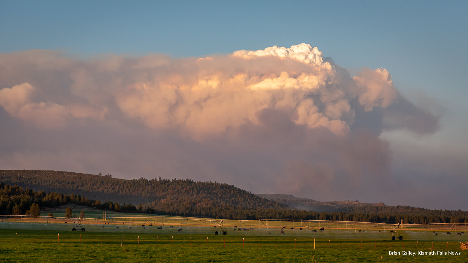
The Bootleg Fire has now grown to nearly 150,000 acres in just five days. (Image: Brian Gailey, Klamath Falls News.)
FIRE DETAILS
Cause:
Under investigation
Size:
143,607 Acres
Containment: 0%
Location:
North of Sprague River & Beatty, Ore.
Resources:
Personnel: 926
Hotshot Crews: 3
Type II Attack Crews: 6
Type II Crews: 10
Hand crews: 19
Engines: 83
Dozers: 6
Water Tenders: 25
Aircraft:
Helicopters 10
Fuels:
Heavy Timber, grass, and understory.
Incident Commanders:
Al Lawson
Lance Lightly
Initial Report:
1:45 PM, July 6, 2021
Coverage of the 2021 Wildfire Season is brought to you by Ace Towing.
KLAMATH COUNTY, Ore. - After the fifth extreme fire day in a row, firefighters had to retreat as the flames became too much yesterday. The intense fire behavior escalated in the afternoon, resulting in immediate life-threatening risk to the public and emergency responder safety.
Conditions were so extreme that firefighters needed to disengage and move to predetermined safety zones. Fire managers evaluated conditions and looked for opportunities to reengage firefighters safely.
Overnight an infrared aircraft flew over the fire and confirmed what everyone feared, the fire doubled in size again. The fire is now 143,607 acres, the largest fire in the nation, and still growing. Hot & dry weather and extremely dry fuels have contributed to the fire’s behavior.
“I saw three separate columns of smoke yesterday on the Bootleg Fire,” said Klamath County Sheriff, Chris Kaber as he showed KFN publisher, Brian Gailey photos on his phone Saturday night.
Two Type 1 Teams are being added to manage the fire as well as a “surge force” of structure protection is also arriving. Currently, 926 personnel are now working the fire.
This extreme fire behavior resulted in approximately 4 miles of fire growth both to the east and north. The fire moved through Sycan Estates, crossed the East-West road, and burned about 8 additional miles along the high voltage powerline corridor, for a total of 12 miles. Damage to structures and infrastructure is being assessed; some structures have been lost. There have been no reported fatalities.
On the southwest side of the fire, light winds and lighter fuel conditions allowed firefighters, structure protection teams, and air support to be successful in minimizing fire growth toward the south (communities of Klamath Forest Estates/Moccasin Hills, Tablelands).
Western movement of the fire toward Chiloquin was also minimal.
TODAY’S OPERATIONS
While firefighting and containment efforts continue through the day, fire managers are adding more crews to night shift because weather conditions are better for fighting the fire as well as for building containment lines.
Crews are also working on structural triage, defensible space and protection.
Following yesterday’s significant fire growth, crews are scouting new locations for safe, effective primary and secondary containment lines around the entire fire perimeter.
Aircraft (helicopters and fixed wing water and retardant drops) are being used to assist on-the-ground crews. However, flights will be grounded if any type of drone activity is spotted in the area.


EVACUATION INFORMATION
Due to rapid-fire movement, evacuation areas and levels are being updated as conditions change. The fastest way to find the latest information on evacuations is to subscribe to the Klamath County Sherriff’s office Emergency Alerts at: http://Alerts.KlamathCounty.org and/or visit the evacuation map.
Evacuation Center
Klamath County Fairgrounds (in Klamath Falls), South 6th Street entrance only.
EVACUATION ORDERS AS OF 7/11/21 on 10:30 a.m.
Level 3 (GO NOW) EVACUATION NOTICE
Klamath County, north of the town of Beatty. East side of Godowa Springs Rd north of the OC and E Trail to the Klamath County Line. is under LEVEL 3 (GO NOW) Evacuation Notice.
Level 3 (GO NOW) EVACUATION NOTICE
Klamath County, near the town of Sprague River. Upper tableland area north of Oregon Pines Rd are under level 3 evacuation notice and need to leave immediately.
Level 2 (GET SET) Evacuation Notice
Klamath County, near the town of Sprague River. Klamath Forrest Estates/Moccasin Hills Area is under level 2 (GET SET) evacuation notice and need to be prepared to leave.
Level 2 (GET SET) Evacuation Notice
Klamath County, West side of Godowa Springs Rd, south of Oregon Pines Rd and Tableland rd. to the river is under level 2 (GET SET) evacuation notice and need to be prepared to leave.
Level 1 (BE READY) Evacuation Notice
Klamath County, Between Beatty and Bly 3 miles south of Highway 140 from Yellow Jacket Springs to Fishhole Creek is under Level 1 (BE READY) Evacuation Notice.
Level 1 (BE READY) Evacuation Notice
Klamath County, The area from the intersection of Sprague River Rd and Forbes Rd extending east to Godowa Springs and Yellow Jacket Springs and south of the Sprague River 4 miles is under Level 1 (BE READY) Evacuation Notice.
PUBLIC AND FIREFIGHTER SAFETY
There is a high potential for extreme fire behavior and movement on all sides of the fire. The Klamath County Sheriff’s Office has begun to issue citations and will make arrests if necessary to keep people out of the level 3 evacuation areas.
People have been advised to evacuate over the last several days, some have not listened and continue to travel within the restricted area. This violates the closure restrictions and interferes with firefighting and lifesaving efforts.
Residents in Level 3 Evacuation Area PLEASE EVACUATE IMMEDIATELY. There is a VERY high probability officers may not be able to get to you with additional warnings.
Watch for increased fire equipment traffic on area roads and highways. Do not fly drones in the vicinity of the fire; drone activity will cause grounding of all airborne firefighting resources.
PUBLIC INFORMATION
Today, fire and county officials will be at the following sites to provide information and answer questions. Because the team will make multiple stops, the times listed are approximate.
Sprague River Community Center, 1 – 1:30 p.m.
Beatty Community Center, 1:45 – 2:15 p.m.
Bly Community Center, 2:30 – 3 p.m.
Paisley at 1032 West Street, 4:30 – 5 p.m.
Summer Lake Lodge at 53460 Highway 31, 5:30 – 6 p.m
Fire information boards, updated daily, are located at:
Chiloquin:
Public Parking Lot
Crater Lake Junction Travel Center (KLA-MO-YA Casino)
Beatty:
Community Center
Sprague River:
Community Center
Bly:
Ranger District Office
Breadwagon
Klamath Falls:
Klamath County Fairgrounds Red Cross Evacuation Center
SMOKE
Smoke is expected to continue to impact the local area. If you are sensitive to smoke, check air quality levels at https://fires.airfire.org/outlooks/southcentraloregon.
CLOSURES
Map of the Emergency Fire Closure [click to enlarge]
The Fremont-Winema National Forest has issued a closure area on National Forest System land between Forest Roads 4542 and 45 on the western edge, north to the Forest Boundary at Head of the River Campground, then following the Forest Boundary east to the Sycan Marsh area, then south around Forest Road 30, also known as Ivory Pine Road, down along the Forest Boundary, before turning west and following to Forest Road 44 and then north to the junction with Forest Road 4542.
Additionally, Forest Road 44 is closed from Sprague River Road east to the junction with Forest Road 4542.
Forest Road 30 is closed as a result of the order. Those traveling into the area from the east side are advised to not go further west on Forest Road 30 than the junction with Forest Road 28 at Currier Guard Station.
Head of the River Campground, Sycan Ford Picnic Area and Horseglade Trailhead are within the closure area.
HOW BIG IS THE BOOTLEG FIRE?
As of today, July 11, 2021, the Bootleg Fire is the largest fire burning in the State of Oregon at 143,607 acres. The fire is equal to 224.4 square miles. That is larger than the Archie Creek fire in Douglas County in 2020 but smaller than the entirety of Crater Lake National Park, and ten times the size of the 242 Fire that burned in Chiloquin last summer.
Information is provided by the Fremont-Winema National Forest, Klamath County Emergency Management, Oregon Department of Forestry, and Northwest IMT 10 is current as of 11:40 AM, July 11, 2021.
Klamath Falls News will continue to follow the situation and provide updates as they become available.
RELATED:
July 10, 2021
July 9, 2021
July 8, 2021
July 7, 2021
July 6, 2021
July 6, 2021

Klamath Falls News & Cascade Firewatch’s coverage of the 2021 Wildfire Season is brought to you by Ace Towing.
Ace Towing offers 24-hour emergency roadside assistance, collision towing, jump starts, lockouts, fuel, and tire changes. They also make automotive keys and program fobs too. 541-884-9388.
We are currently looking for additional sponsors for coverage of the 2021 Fire Season. Would your business like to sponsor our coverage of the 2021 Wildfire Season? Send us a note at klamathfallsnews.org/contact for more information.