Morgan Fire containment 60 percent
/
Rainbow over the Morgan Fire. (Image: Inciweb)
FIRE DETAILS
CAUSE:
Under investigation
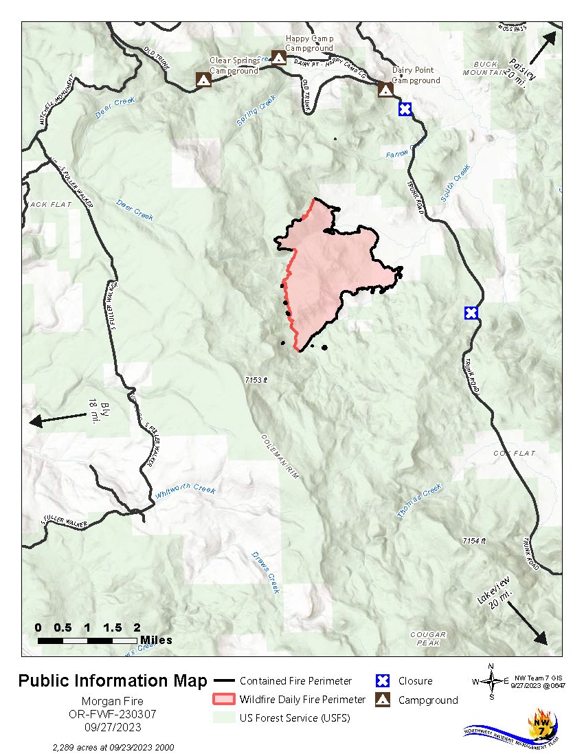
SIZE: 2,289 acres
CONTAINMENT: 60%
START DATE:
September 18, 2023
EXPECTED CONTAINMENT DATE:
October 15, 2023
LOCATION:
8 miles north of Quartz Mountain
INCIDENT COMMAND:
NWIMT 7
RESOURCES:
Aircraft: 1
Hand crews: 8
Engines: 7
Dozers: 4
Water Tenders: 7
Personnel: 314
FUELS:
Timber and brush
Last Updated:
9:30 AM, 9/27/23
LAKEVIEW, Ore. - Yesterday, firefighters found a single spot fire across the containment line on the north end resulting from the strong dry winds and successfully contained and mopped it up.
Crews gained additional containment and established deeper mop-up around the fire, and began fire line repair. The infrared detection unmanned aerial platform (drone) was used overnight and did not detect any new areas of heat requiring attention.
Today, Firefighters will mop-up and secure fire line, remove felled hazard trees, and continue repairing dozer and hand lines. Repair consists of returning the disturbed areas, fire lines, staging areas, helipads etc., to as natural a state as possible. This is to minimize any future damage or impacts to the watersheds due to erosion.
Heavy equipment is used to pull back the removed natural vegetation over the dozer lines to protect the soil and make it easier for the ground to recover.
Evacuations
There is currently a Level 1 (“Get Ready”) Evacuation. Be wildfire aware! Avoid activities that can cause an accidental spark.
Temporary Road Closure
The Fremont-Winema National Forest issued a temporary closure for public safety on a segment of Forest Service Road 2800, between its junction with Forest Road 3428 on the north and Forest Road 2800-016 on the south. A copy of the order and map is on the Forest website: https://www.fs.usda.gov/fremont-winema

A skidgen works along a dozer line on the west side of the Morgan Fire. (Image: Inciweb)
Weather
A few light rain showers are possible early Wednesday morning, however generally dry weather is expected through Thursday with lighter, more seasonable winds. Cooler air will filter into the area, with overnight temperatures at or below freezing beginning Wednesday night through the weekend.
Weather concerns
A few light rain showers are possible early Wednesday morning, however generally dry weather is expected through Thursday with lighter, more seasonable winds. Cooler air will filter into the area, with overnight temperatures at or below freezing beginning Wednesday night through the weekend. Additional chances for light precipitation Friday into the weekend with high relative humidity.
Maps
Outlook
Planned Actions:
Direct line construction, snagging hazard trees, mop-up and secure fireline, and contingency planning.
Projected incident activity:
12 hours: Winds decreasing with possible wetting rains which will lead to decreased fire activity.
24 hours: Cool temperatures with higher recovery will keep fire activity to a minimum.
Remarks:
Northwest Incident Management Team 7 assumed command of the incident on 9/21/23 at 7:00 AM.
CASCADE FIREWATCH IS SPONSORED BY