Morgan Fire over 2200 acres near Quartz Mountain
/
The Morgan Fire as seen from Forest Service Road 28 and South Creek. Firefighters are focusing on strengthening existing containment lines today in anticipation of wind gusts in excess of 45 miles per hour over the next two days. (Image: Inciweb)
FIRE DETAILS
CAUSE:
Under investigation
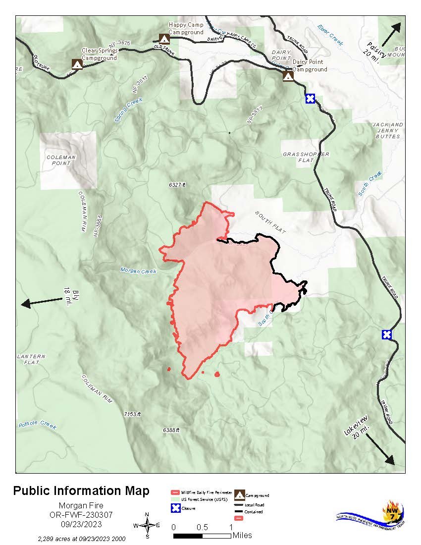
SIZE: 2,289 acres
CONTAINMENT: 35%
START DATE:
September 18, 2023
EXPECTED CONTAINMENT DATE:
October 15, 2023
LOCATION:
8 miles north of Quartz Mountain
INCIDENT COMMAND:
NWIMT 7
RESOURCES:
Aircraft: 3
Hand crews: 8
Engines: 11
Dozers: 5
Water Tenders: 8
Personnel: 352
FUELS:
Timber and brush
Last Updated:
10:30 AM, 9/24/23
LAKEVIEW, Ore. - The Morgan Fire is burning in steep, forested terrain, approximately 21 miles northwest of Lakeview, Oregon, and 8 miles north of Quartz Mountain, on both private and National Forest System lands is now measured at 2,289 acres with 35% containment.
Yesterday, Firefighters focused on preparing for significant winds forecast to begin early today. A fireline is complete around the entire perimeter, and crews work to extinguish any heat sources within 50 feet of the perimeter.
Additional hazard tree felling was a high priority to ensure that firefighters would have safe access and egress if high winds caused fire-weakened trees to fall across roads.
Today, fire crews will deepen their mop-up operations along the perimeter and continue felling hazard trees. An infrared detection unmanned aerial system (drone) is used to find any hidden heat sources that could threaten fire lines in windy conditions.
Evacuations
There is currently a Level 1 (“Get Ready”) Evacuation. Be wildfire aware! Avoid activities that can cause an accidental spark.
Temporary Road Closure
The Fremont-Winema National Forest issued a temporary closure for public safety on a segment of Forest Service Road 2800, between its junction with Forest Road 3428 on the north and Forest Road 2800-016 on the south. A copy of the order and map is on the Forest website: https://www.fs.usda.gov/fremont-winema
Weather
Increasing winds beginning this morning from the south-southwest with gusts 25-35 mph over the fire area. There is a chance for light scattered spotty rain through today.
Weather concerns
Temperatures warmed in the upper 60s to low 70s across the Morgan Fire today; 5-10 degrees warmer than Friday. Daytime minimum relative humidity fell to around 18-25%, coupled with increasing west-southwest winds, gusting 15-22 mph throughout the afternoon. Expect winds to increase further Sunday and shift more south southwesterly. Sustained winds up to 15-25 mph are likely with gusts 25-35 mph Sunday afternoon. Winds will remain elevated overnight Sunday into Monday before stengthening again Monday.
Gusts out of the south-southwest of 35-45 mph are likely across the fire area, especially on higher, exposed ridges. Spotty precipitation is possible Sunday, with a higher (~60-70%) chance of showers Monday into Tuesday. Total rainfall amounts Monday-Tuesday of around 0.05-0.2 inches, locally higher amounts possible.
Maps
Outlook
Planned Actions:
Direct line construction, snagging hazard trees, mop-up and secure fireline, and contingency planning.
Projected incident activity:
12 hours: Cooler temperatures, high humidity are likely to keep fire behavior at minimal levels.
24 hours: Wind event could lead to increased fire activity if fire moves outside containment lines. Increased drying forecasted with wind which will lead to lower RH.
Remarks:
Northwest Incident Management Team 7 assumed command of the incident on 9/21/23 at 7:00 AM.
CASCADE FIREWATCH IS SPONSORED BY