O'Connor Fire burns 2 acres on the Klamath Hills; 20 new fires reported
/
O’CONNOR FIRE DETAILS
Cause:
Lightning
Size:
2.1Acres
Containment:
Wet line: 100%
Location:
Klamath County, Oregon
Fuels:
Grass, sagebrush, juniper
Last Updated:
2:30 PM, 8/9/22

Twenty new fires have been reported inside the SCOFMP area
KLAMATH FALLS, Ore. - Late yesterday evening a fast-moving thunderstorm left its mark on the Klamath Basin. Sparking the O’Connor Fire on Klamath Hills and numerous additional holdover fires that were discovered this morning.
The South Central Oregon Fire Management Partnership (SCOFMP) has listed twenty new fires on their incident page since 7:00 AM yesterday. Sixteen of which are new fires since Monday’s thunderstorm.
The most visible and largest of these fires was the 2.1-acre O’Connor Fire located eleven miles south of downtown Klamath Falls in the Klamath Hills area. Located halfway up the hillside, the fire burned grass, sagebrush, and juniper.
Crews from Klamath County Fire District 1 were dispatched around 9:30 PM, Monday. Firefighters had to hike into the fire due to steep terrain, and few available roads for apparatus.
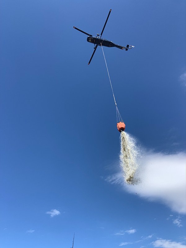
The Oregon Department of Forestry also responded with hand crews. After dawn on Tuesday, ODF was able to dispatch a helicopter with a water bucket to aid in fighting the fire.
Jennifer Case, Oregon Department of Forestry provided an update stating, “The O’Conner fire still at 2 acres, 100% lined 60% mopped up. Crews are working with little water, however, Helicopter 8AH is doing bucket work. They should have it 100% mop-up by late afternoon.”

![Image[2].jpeg](https://images.squarespace-cdn.com/content/v1/59b9f24c64b05fd6531db026/1660081047190-32F3K32OTLK79KVBS016/Image%5B2%5D.jpeg)
![Image[3].jpeg](https://images.squarespace-cdn.com/content/v1/59b9f24c64b05fd6531db026/1660081054360-Q5EANT1WX6983AH50HSL/Image%5B3%5D.jpeg)
![Image[5].jpeg](https://images.squarespace-cdn.com/content/v1/59b9f24c64b05fd6531db026/1660081514368-ID70P1IEGEPNSTBZ2XB2/Image%5B5%5D.jpeg)
![Image[6].jpeg](https://images.squarespace-cdn.com/content/v1/59b9f24c64b05fd6531db026/1660081518208-UXIGB1HCYQFE9TA63V2V/Image%5B6%5D.jpeg)
![Image[7].jpeg](https://images.squarespace-cdn.com/content/v1/59b9f24c64b05fd6531db026/1660081516586-5ZRJMA4F3Q3MYIL2C78X/Image%5B7%5D.jpeg)
MAP
Approximate location of the O’Connor Fire.
ADDITIONAL FIRES
SCOFMP Incident Information page (below) lists sixteen new fires located overnight. Of the fires reported, most are 1/10th of an acre in size. The O’Connor Fire has been the largest.

WEATHER
The National Weather Service in Medford is predicting additional thunderstorms this afternoon east of the Cascades from moving northerly from Modoc County to Deschutes County. A Red Flag Warning remains in effect for much of the quad county area through tonight.

Thunderstorms will impact areas from the Cascades near and north of Crater Lake eastward and also southward to Modoc County through this evening. These storms will have the ability to produce frequent cloud to ground lightning, heavy rainfall, small hail, and gusty winds. When thunder roars, go indoors! Go inside a house, car or sturdy building. Do NOT seek shelter under trees, stay away from water and/or metal objects. Since many areas where thunderstorms are expected are very dry, abundant lightning on dry vegetation will increase the risk of new wildfires.

A complex weather pattern will continue to impact the region today through Tuesday. Low pressure lingering just offshore will slowly wobble northeast during this time, bringing very dry and windy conditions to some areas west of the Cascades. At the same time, scattered thunderstorms are expected from the Cascades eastward. All of these elements will result in prime conditions for the rapid spread of any new or existing fires. While it’s important to avoid anything that causes a spark during all of fire season, it’s especially important over the next few days. Do your part and be a responsible citizen.
CASCADE FIREWATCH IS SPONSORED BY