
Tennant Fire reaches 10,000 acres
/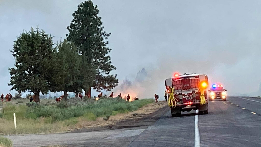
CAL FIRE crews work the #TennantFire along US Highway 97 in the south end of Butte Valley near Mount Hebron. July 1, 2021. (Image: Inciweb)
Map of the #TennantFire showing growth of the fire as of 7:00 AM, July 3, 2021. [click to enlarge]
FIRE DETAILS
Cause:
Under Investigation
Size:
10,012 Acres
Containment: 17%
Personnel: 748
Location:
Mt. Hebron, California
Coverage of the 2021 Wildfire Season is brought to you by Ace Towing.
MT HEBRON, Calif. - Due to effective suppression efforts by Tennant Fire personnel, resources have been able to focus their efforts in containing hot spots on the western and southeastern areas of the fire perimeter.
As of 6:00 AM, July 3, 2021, the fire has burned 10,012 acres and has a containment level of 17%. Fire suppression tactics will continue to be constructing and strengthening direct fire line, as well as preparing for any possible increased fire activity.
California Incident Management Team 15 will be hosting a Community Meeting in partnership with Klamath National Forest, CAL FIRE, and cooperating agencies at 6:00 PM, July 3, 2021, at the Butte Valley Community Center in Dorris. The meeting will also be livestreamed via the Klamath National Forest, Facebook page.
All those seeking more information on the Tennant Fire are invited to discuss any questions or concerns they have regarding the fire. Officials from CAIMT15, CAL FIRE, Klamath National Forest, and local representatives will be available to answer any questions.
With a heat advisory in effect until Sunday, July 4th, resources will be focused on keeping the fire held to its current perimeter and responding to spot fires as quickly as possible. Hot, dry, and breezy conditions will continue through the holiday weekend with lower-to-mid 90’s persisting into early next week. Dry conditions will prevail each afternoon with humidity dropping into lower teens each afternoon.
A slight uptick in moisture on Saturday and Sunday may be enough to trigger an isolated shower or thunderstorm, but overall chances will remain low with about a 5-10% chance of development.
![As of 12:00 PM, 7/3/21 the following Evacuation area remains in effect for areas around the Tennant Fire. For the latest evacuation map https://arcg.is/1CrfH40. [click image to enlarge]](https://images.squarespace-cdn.com/content/v1/59b9f24c64b05fd6531db026/1625338943978-WSU28VBMWCTK7AU4HYMD/20210703-TennantFireEvacMap.jpg)
As of 12:00 PM, 7/3/21 the following Evacuation area remains in effect for areas around the Tennant Fire. For the latest evacuation map https://arcg.is/1CrfH40. [click image to enlarge]
US Highway 97 remains closed between Dorris, Calif. and Weed, Calif. due to active fire suppression activity on both the Tennant Fire and the Lava Fire 3.5 miles north of Weed. Old State Highway is also closed around the Tennant Fire.
Evacuation Orders and Warnings are in effect for areas surrounding the Tennant Fire. Up-to-date information regarding evacuations can be viewed at an interactive map managed by the Siskiyou County Office of Emergency Services: https://arcg.is/1CrfH40.
The cause of the Tennant Fire was originally reported as a vehicle fire but now has been changed to under investigation.
Outlook
PLANNED ACTIONS
Crews continue to construct and strengthen direct fire lines, construct indirect fire line in anticipation of possible burning operation, and construct contingency fire line to protect assets at risk.
PROJECTED INCIDENT ACTIVITY
12 hours: Most of fire growth will continue to be along the eastern perimeter as it spreads to the east towards the Old State Highway and the communities of Bray, Tennant, Mt. Shasta Woods, Juanita Lake, and Shafter Campground are threatened. Critically dry fuels and heavy accumulation of dead and downed trees continue to pose a threat to private timber lands to the west. The fire continues to keep highway 97 closed and threaten the railway corridor.
24 hours: Crews will continue to secure the fires perimeter on the western flank, look for opportunities for direct line placement on the eastern flank, and build contingency lines in preparation in case the direct line is not feasible.
48 hours: Similar threat is expected.
72 hours: Anticipated after 72 hours: If crews are successful with their line construction efforts the majority of the threat to Hwy 97 and the railroad will be mitigated.
Klamath Falls News & Cascade Firewatch’s coverage of the 2021 Wildfire Season is brought to you by Ace Towing.
Ace Towing offers 24-hour emergency roadside assistance, collision towing, jump starts, lockouts, fuel, and tire changes. They also make automotive keys and program fobs too. 541-884-9388.
We are currently looking for additional sponsors for coverage of the 2021 Fire Season. Would your business like to sponsor our coverage of the 2021 Wildfire Season? Send us a note at klamathfallsnews.org/contact for more information.