
Wet and Windy Weekend Ahead
/
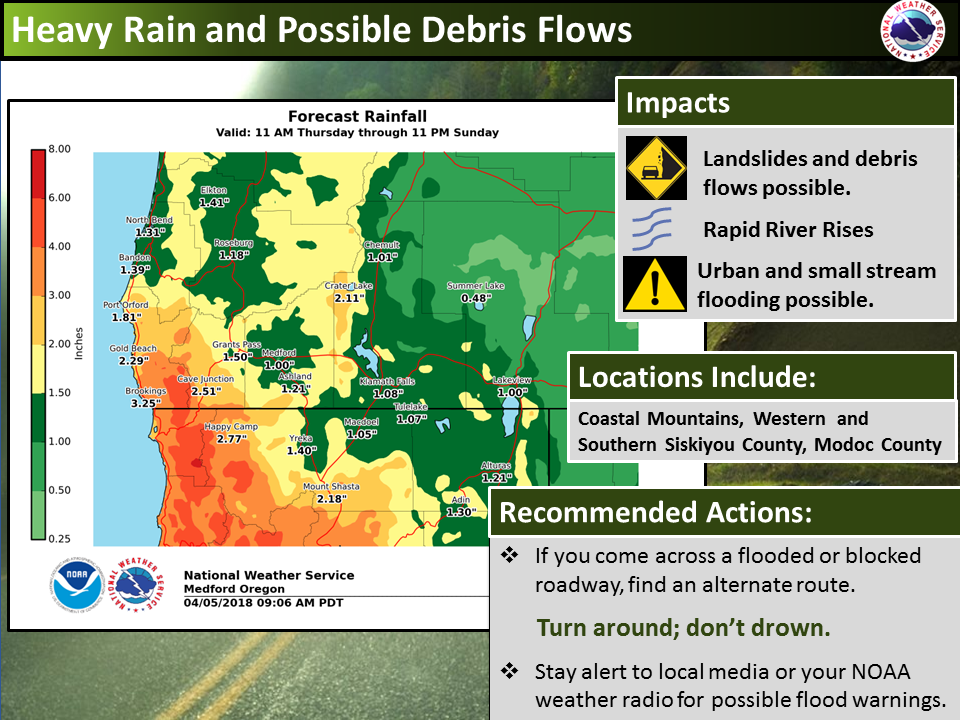
Heavy Rain and Debris Flows
Two storm systems will arrive back to back and bring periods of heavy rain to southern Oregon and northern California over the next several days. Snow levels will quickly rise to about 8000 feet early on Thursday and will linger there through Saturday before falling to around 5000 feet. This heavy rain will create the possibility for land slides and debris flows, rapid river rises and urban and small stream flooding.
It is worth noting that this system is rather unusual for this time of year and will provide many places east of the Cascades, particularly for Modoc County, most of their usual April monthly rainfall in 3 days. If you come across a flooded roadway, find an alternate route. Remember to turn around, don’t drown. Stay tuned to local media or your NOAA weather radio for possible flood warnings.

Very Windy Saturday through Saturday Night
Expect occasional strong winds across portions of southern Oregon and northern California tonight through Monday Night. Winds will peak Saturday afternoon and evening as low pressure moves north along the coast. The worst conditions are expected across the east side, through the Shasta Valley, and along the coast.
However, all areas are expected to see at least a period of strong, gusty winds. Travel on Interstate 5 as well as highways, 31, 39, 97, 101, 140, and 395 could become difficult—particularly for high profile vehicles. Remember to slow down and use extra caution when driving. Additionally, there may be isolated cases of downed trees or power lines. Loose objects may be blown away or damaged due to the winds.
DANGEROUS Beach & Ocean Conditions This Weekend
Very high seas and dangerous surf will impact the coast and marine waters through Saturday. 20 to 25 foot breakers are expected at the peak of this event with waves possible in south facing beach parking lots.
In addition, sneaker waves will be possible, especially on Sunday. Stay off jetties, logs, and rocks. Never turn your back to the ocean. If you are swept into the ocean, you only have 10 minutes in 50 degree water before your legs, arms, and hands are unable to make any meaningful movements.
| 3-Day Forecast - Klamath Basin | |
|---|---|
| TONIGHT | Rain. Low around 44. South wind 14 to 20 mph, with gusts as high as 29 mph. Chance of precipitation is 100%. New precipitation amounts between a quarter and half of an inch possible. |
| SATURDAY | Rain likely before 11am, then a chance of showers after 11am. Partly sunny, with a high near 49. Windy, with a southwest wind 25 to 34 mph, with gusts as high as 50 mph. Chance of precipitation is 60%. New precipitation amounts between a tenth and quarter of an inch possible. |
| SATURDAY NIGHT | A chance of rain showers before 11pm, then a chance of rain and snow showers. Mostly cloudy, with a low around 35. Breezy, with a west southwest wind 23 to 29 mph, with gusts as high as 44 mph. Chance of precipitation is 40%. Little or no snow accumulation expected. |
| SUNDAY | A slight chance of rain and snow showers before 11am. Mostly cloudy, then gradually becoming sunny, with a high near 52. West wind 11 to 18 mph, with gusts as high as 28 mph. Chance of precipitation is 20%. |
| SUNDAY NIGHT | Mostly clear, with a low around 29. West northwest wind 5 to 8 mph becoming light and variable in the evening. |
| MONDAY | Patchy fog before 11am. Otherwise, sunny, with a high near 68. |
| MONDAY NIGHT | Partly cloudy, with a low around 42. |
Information provided by the National Weather Service, Medford, Ore.