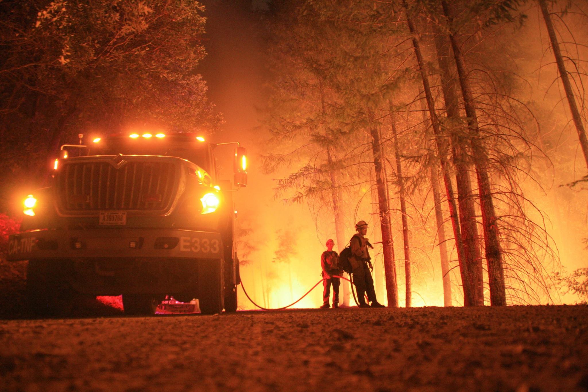
Poker Fire grows to 15,000 acres due to high winds

Poker Fire grows to 15,000 acres due to high winds

Lakeview, Ore. – The Poker Fire was discovered around 11:00 AM on September 15, 2019, and has grown to approximately 15,000 acres.  Fire suppression resources are on scene actively suppressing the fire and additional resources are on order.  High winds made it difficult for fire resources to contain the fire Sunday but with the predicted rains coming firefighters are hopeful they can get some containment of the Poker Fire by Monday evening.  As of Monday morning the fire has received light precipitation.

Read More

BLM Northwest Oregon District Needs Campground Hosts

BLM Northwest Oregon District Needs Campground Hosts

The Bureau of Land Management Northwest Oregon District is looking for spring and summer campground hosts at several of their recreation sites. Recreation sites are a great example of how the BLM serves the American family by being good neighbors, supporting traditional land uses such as grazing, and providing access to hunting, fishing, and other recreational opportunities.

Read More

Public Meeting Set in Lakeview for PEIS on Fuel Breaks & Restoration

Public Meeting Set in Lakeview for PEIS on Fuel Breaks & Restoration

The Bureau of Land Management will hold 14 public meetings in six western states to identify issues and receive public comments. The purpose of these meetings is to gather input for the preparation of two Programmatic Environmental Impact Statements (PEIS) aimed at reducing wildfires and restoring sagebrush steppe habitat.

Read More

BLM Waives Most Day Use Fees in Observance of Martin Luther King, Jr. Day

BLM Waives Most Day Use Fees in Observance of Martin Luther King, Jr. Day

In order to increase recreational access to public land, the Bureau of Land Management will waive recreation-related fees for visitors to public lands on Martin Luther King, Jr. Day, January 15, 2018.

"On Monday, to honor the legacy of Dr. Martin Luther King, Jr., the BLM invites families to spend the day together enjoying America's rich public lands heritage," said Brain Steed, BLM Deputy Director. "Most of these lands are just a short drive from your community. Our fee-free days are a way to encourage our neighbors to enjoy a family outing while reflecting on the American values that have made America great."

Read More

BLM Examining Fuel Projects to Improve Firefighting Capabilities, Protect Rangelands in Great Basin

BLM Examining Fuel Projects to Improve Firefighting Capabilities, Protect Rangelands in Great Basin

The Bureau of Land Management is initiating environmental analyses of fuel breaks, fuels reduction and habitat restoration projects on sagebrush steppe rangelands in Idaho, Nevada, Oregon, Washington, Utah and California to ensure healthy, productive working landscapes and wildlife habitats.

Region-wide analysis of impacts and cumulative effects will help the BLM streamline authorization of projects aimed at reducing the threat of wildfires and restoring degraded habitats.

"Fire, invasive annual grasses and conifer encroachment are the most significant threats to sagebrush-steppe in the Great Basin," said BLM Idaho State Director Tim Murphy. "Focusing on these threats is also going to help the BLM protect working landscapes that contribute to healthy local economies."

Read More

BLM Releases Annual Almanac

BLM Releases Annual Almanac

The Bureau of Land Management (BLM) in Oregon and Washington is proud to announce the latest BLM Facts, our annual illustrated almanac answering the diverse and detailed questions one may have about public lands in the Pacific Northwest. The BLM continues to serve the American family by being good neighbors, supporting traditional land uses such as grazing, and providing access to hunting, fishing, and highlighting these uses through publications like BLM Facts.

Read More

BLM Seeks Nominations to Resource Advisory Councils in Oregon

BLM Seeks Nominations to Resource Advisory Councils in Oregon

The Bureau of Land Management continues to seek public nominations for positions on four Resource Advisory Councils in Oregon. As published in a notice in the Federal Register, the BLM is considering nominations for 30 days, until Dec. 1, 2017. 

Read More

KCC to Host Wildland Firefighter Open House

KCC to Host Wildland Firefighter Open House

KLAMATH FALLS – Klamath Community College will host its second Wildland Firefighter Round-up this month.

This open house is aimed at connecting local job seekers to seasonal wildland firefighting positions available in the Klamath Basin region. The event is at KCC Oct. 27, 2 to 5 p.m., in the Work Skills Technology Center, room 820.

Read More

History Hike Explore Old Wagon Roads

History Hike Explore Old Wagon Roads

KLAMATH FALLS, Ore. – A guided history hike in the Klamath River Canyon on Oct. 28 will explore long-abandoned wagon roads that preceded the relatively modern Topsy Grade road.

The hike, rated as moderate to difficult, is cosponsored by the Klamath County Museum, the Bureau of Land Management Klamath Falls Resource Area, and the Klamath River Four Wheel Drive Association.

Read More

Successful prescribed fire treatment in the Burnt Creek Area

Successful prescribed fire treatment in the Burnt Creek Area

LAKEVIEW, Ore. – A successful day of prescribed fire was accomplished yesterday on the Lakeview Ranger District of the Fremont-Winema National Forest with 405 acres treated in the Burnt Willow project area located 6 miles east of Lakeview.

Fire managers are preparing to continue the prescribed burning operation tomorrow in the Burnt Creek area if weather conditions permit, with a plan for 157 acres of accomplishment for the day.

Smoke may be visible to residents and visitors in the Lakeview area.  Prescribed fires on are public lands is part of the continued commitment to protect communities and natural resources from wildfires.

Read More

Husband and Wife Deceased in Plane Crash in Klamath County

Husband and Wife Deceased in Plane Crash in Klamath County

**Update**
The plane has been identified as a Cirrus SR-22 and the investigation is still continuing to determine the cause and who was the pilot. An aerial photo has been added to the release.

On October 1, 2017 at 10:43 AM, an Oregon State Police Fish and Wildlife Trooper was working with a volunteer between Burton Butte and Old Baldy Mtn. in a remote section of western Klamath County near the Pacific Crest Trail when they heard a low flying airplane. The plane sounded as if it was having engine trouble. The cloud cover was at treetop level and the airplane was not visible.

The plane was heard making impact to the ground less than a mile away. First responders immediately started getting resources en route to assist and locate the plane. An initial check of the area by Troopers and subsequent searches by Search and Rescue were unable to locate the plane. Weather conditions improved, but it wasn't until the morning of October 2nd before a helicopter was able to spot the wreckage and rescuers made their way through the thick timber to the location.

Read More

BLM Offers Livestock Operators Increased Flexibility Through Outcome Based Grazing Authorizations

Image: BLM

Image: BLM

The Bureau of Land Management announced a new initiative today to provide grazing permit holders an unprecedented level of flexibility in the management of livestock while also protecting the public lands. This effort emphasizes the Trump Administration's goal of promoting shared conservation stewardship of public lands while supporting uses such as grazing.

"Farmers and ranchers know the wildlife and the land they work better than anyone, it only makes sense that we would enlist them in conservation efforts," said Department of the Interior Secretary Ryan Zinke. "One of my top goals is for the government to be a better neighbor, land manager, and partner. I think it's is a great step in that direction. I applaud the team at BLM for coming up with this innovative program."

Under the demonstration program, the BLM will work with grazing permittees and other stakeholders in identifying 6 to 12 "Outcome-Based Grazing Authorizations" in its first year. Grazing authorizations typically emphasize process and prescription. The new authorizations will instead emphasize ecological outcomes, allowing livestock operators more flexibility to make adjustments in response to changing conditions such as drought or wildland fire. This innovative concept is intended to develop and determine the effectiveness of these permits to manage livestock grazing on public lands in order to meet both natural resource and operational objectives.

"This initiative is in line with the Administration's priority promoting shared stewardship of public lands and giving local stakeholders a say in how these lands are managed," said Michael D. Nedd, acting BLM Director. "This demonstration project will allow permittees and the BLM to work together more efficiently and effectively to support sustainable grazing operations."

The new authorizations will emphasize conservation performance, ecological outcomes and cooperative management of public lands that will also provide greater opportunity for an operator to manage ranching operations that are both economically and environmentally sustainable.

Through this new demonstration program, the BLM plans to work with permit holders and other stakeholders to show that livestock grazing on the public lands can operate under a more flexible framework than is commonly used in order to better reach agreed upon habitat or vegetation goals. The BLM and its partners in the grazing community will share experiences and best practices that will determine if additional authorizations can be successful in the future.

The BLM administers nearly 18,000 permits and leases held by ranchers who graze their livestock (mostly cattle and sheep) on more than 21,000 allotments. Livestock grazing occurs on 155 million acres of public lands.

The BLM will solicit project proposals through its state offices with a deadline of Oct. 13.

--BLM--

The BLM manages more than 245 million acres of public land, the most of any federal agency. This land is primarily located in 12 Western states, including Alaska. The BLM also administers 700 million acres of sub-surface mineral estate throughout the nation. The BLM's mission is to sustain the health, diversity, and productivity of America's public lands for the use and enjoyment of present and future generations.

Press release from the Bureau of Land Management

700 Sixth Graders Tour the Forest

Michelle Cottier a firefighter with ODF geared up Feanix Hightower of Chiloquin Elementary and instructs her how to use the fire hose of Oregon Department of Forestry Engine 8150 at the 54th Annual Klamath County Forest Tour. Image: B…

Michelle Cottier a firefighter with ODF geared up Feanix Hightower of Chiloquin Elementary and instructs her how to use the fire hose of Oregon Department of Forestry Engine 8150 at the 54th Annual Klamath County Forest Tour. Image: Brian Gailey

Keno Ore. - Located 11 miles out side of Keno Oregon near the Spencer Creek Drainage off Clover Creek Road is the Klamath Forestry Tour. For the past 54 years, this tour has been educating Klamath County sixth graders through individual stations about; forest products, recreation, survival, reforestation, tree identity, soils, water, forest management, fire suppression and wildlife.

"Sixth graders spend two days in the forest, learning about the forest...after 54 years we are expecting the great grandchildren of the original students that attended all those years ago to attend this week." Daniel Leavell.

Leavell adds, "It's a wonderful way to get to know the forest and uses of the forest and to teach them about different aspects of the forest environment."

Students arrived by bus to the location where they lined up to head to the different stations. Each station taught the classes something different about the forest.

At the Tree Identity station, Mr. Mike McKittrick and his students from Ferguson Elemtary learned how to use a classification diagram to determine if a tree was a True Fir or a Douglas Fir. Students also were able to identify what a Sugar Pine is as well.

At the soil station, Mrs. Kay Linmans' class from Henley Elementary learned about different layers of soil and how they impact all living things above ground.

Students from all local elementary schools were able to participate in this program. Students from Mrs. Sara Thomas' sixth grade class from Triad were able to hear about survival techniques if they were to become lost in the woods.

"We think of ourselves as being a rural area, but it is surprising how many kids in town, that this is their only experience out here. Getting out into the forest and seeing what really goes on." says Ron Loveness.

At the forest management station, Patrick Peterson and Jennifer Case from the Oregon Department of Forestry obtained a core sample from a fir tree. This core sample, was then used to educate the kids on how a tree can be aged without being harvested. This technique is used to better understand the forest and help selectively harvest trees for a healthier forest.

The tree they captured a sample on counted to be 96 years old. That means when the Forestry Tour started in 1963, that fir was a young 42 years old.

VIDEOS
Live Interview - http://bit.ly/2fmZSwj
Reforestation - http://bit.ly/2fmUaL4 
Forest Management - http://bit.ly/2fmZL3R
Recreation / Survival - http://bit.ly/2fmvNNg

LIVE: Klamath County Forest Tour

Keno Ore. - 2017 marks the 54th Annual edition of the Klamath County Forest Tour. In this video we interview Daniel Leavell and Ron Loveness about the tour and what Klamath County sixth graders are experiencing and learning.

Six grade elementary students throughout Klamath County come out to Keno every September to tour our counties forests and to learn about from field experts. Stations include - Forest Products, Recreation, Reforestation, Tree Identity, Soils and Water, Forest Management, Fire Supression, and Wildlife.

Wildfire Update - High Cascades Complex, East Zone

The High Cascades Complex East Zone includes the Spruce Lake, Blanket Creek, and North Pelican fires. A dry cold front is moving into the area today with cooler conditions and gusty winds up to 15 miles per hour. The cooler temperatures and abundant sun will remain through the weekend with low temperatures down to freezing. Smoke plumes may be visible due to lower relative humidity but expected fire growth will be minimal.

🔥 Spruce Lake Fire (15,789 acres and 27% contained) The fire showed minimal fire behavior as crews continue to strengthen the fire lines. Chipping operation will be completed today.

🔥 Blanket Creek Fire (31,632 acres and 20% contained) Crews continue to hold and strengthen containment lines to the north and east. Structure protection continues as we assess the values at risk in Mazama Village in Crater Lake National Park. The northwest side of the fire is nearing containment. Crews will be looking to perform burn out operations with the expected weather conditions on the east end of the fire.

🔥 North Pelican (3,589 acres and 25% contained) Crews continue to work to the north building containment lines on the fires perimeter pushing the fire into the wilderness. Crews are also working with heavy equipment to expand indirect line.

A Level 1 Evacuation Notification remains in effect for Mazama Village in Crater Lake National Park. Level 1 is the first step in the “Be Ready, Be Set, Go!” system. For more information about evacuation levels and procedures, go to http://tinyurl.com/BeReady-BeSet-Go.

Closure Information: As a result of the fires in the High Cascades Complex, a number of area road and trail closures are in place within Crater Lake National Park, Rogue River-Siskiyou, Umpqua, and Fremont-Winema National Forests. More road and trail closures may go into effect as the fires progress. For specific closure information, visit https://inciweb.nwcg.gov/incident/5503.

The North Entrance Road to Crater Lake National Park remains closed. West Rim Drive will reopen on Friday at 4:00 pm. All concession facilities and services remain open for visitors to the Park. Motorists and visitors to the area also need to be aware of delays on Hwy 230 between Union Creek and the junction with Highway 138 due to road construction.

Smoke Outlook: A full smoke forecast can be viewed at: https://inciweb.nwcg.gov/incident/5503. To see visibility at Crater Lake National Park, check out the webcams at https://www.nps.gov/crla/learn/photosmultimedia/webcams.htm.

Location: High Cascades Ranger District, Rogue River-Siskiyou National Forest, Klamath Ranger District, Fremont-Winema National Forest, Crater Lake National Park

Start Date: 
• North Pelican August 10, 2017, 
• Spruce Lake July 29, 2017, 
• Blanket Creek July 26, 2017

Cause: Lightning

Size: 51,010 Acres

Percent Contained: 16% (% encompasses total of both East and West zone of the complex excluding Spruce Lake fire from the Complex)

Vegetation: timber, brush, heavy logging slash

Resources Assigned: 845 personnel (Personnel for the entire complex)

Incident Commander: Steve Millert/Dave Gesser with the Southwest Area Type 2 Incident Management Team 3

U.S. Forest Service - Fremont-Winema National Forest
U.S. Forest Service- Rogue River-Siskiyou National Forest
U.S. Forest Service - Umpqua National Forest
Crater Lake National Park
South Central Oregon Fire Management Partnership - SCOFMP
Bureau of Land Management
Rocky Point Fire & Ems
#SpruceLakeFire
#BlanketCreekFire
#NorthPelicanFire
#HighCascadesComplexEast
#HighCascadesComplex

Secretary Zinke Directs Interior Bureaus to Take Aggressive Action to Prevent Wildfire

WASHINGTON – Today, U.S. Secretary of the Interior Ryan Zinke directed all Department of the Interior bureaus, superintendents, and land managers at all levels to adopt more aggressive practices, using the full authority of the Department, to prevent and combat the spread of catastrophic wildfires through robust fuels reduction and pre-suppression techniques.

Image: Orleans Complex Fire (Inciweb)Press Release from US Department of the Interior

Image: Orleans Complex Fire (Inciweb)
Press Release from US Department of the Interior

This year-to-date, 47,700 wildfires have burned 8 million acres across the country, with the majority of the devastation in the states of California and Montana. High-profile fires in Yosemite and Glacier National Parks have caught national headlines, however millions of acres of forest and grassland have burned in recent months.

"This Administration will take a serious turn from the past and will proactively work to prevent forest fires through aggressive and scientific fuels reduction management to save lives, homes, and wildlife habitat. It is well settled that the steady accumulation and thickening of vegetation in areas that have historically burned at frequent intervals exacerbates fuel conditions and often leads to larger and higher-intensity fires," said Secretary Zinke. "These fires are more damaging, more costly, and threaten the safety and security of both the public and firefighters. In recent fire reviews, I have heard this described as 'a new normal.' It is unacceptable that we should be satisfied with the status quo. We must be innovative and where new authorities are needed, we will work with our colleagues in Congress to craft management solutions that will benefit our public lands for generations to come."

The Secretary is directing managers and superintendents of units that have burnable vegetation to address the threat of fire in all of their activities, and to use the full range of existing authorities, to reduce fuels.

Bryan Rice, Director of the Office of Wildland Fire, said, "It is critical to fully consider the benefits of fuels reduction in the everyday management activities that we carry out for our public land management objectives, such as clearing along roadsides, around visitor use areas like campgrounds and trails, near employee housing areas, and within administrative site areas subject to wildfire."

The Department has lost historic structures in wildfires like Glacier National Park's historic Sperry Chalet lodge. In an effort to help prevent future losses, the Secretary is also directing increased protection of Interior assets that are in wildfire prone areas, following the Firewise guidance, writing: "If we ask local communities to 'be safer from the start' and meet Firewise standards, we should be the leaders of and the model for 'Firewise-friendly' standards in our planning, development, and maintenance of visitor-service and administrative facilities."

“I welcome Secretary Zinke’s new directive and his attention to the catastrophic fires taking place in many western states,” said Senator Lisa Murkowski, Chairman of the Senate Energy and Natural Resources Committee. “Treating our landscapes mitigates wildfire risk, increases firefighter safety, and makes our forests and rangelands healthy and resilient. We can no longer delay the implementation of this important work.”

House Natural Resources Chairman Rob Bishop said, "We must ensure our land management agencies have the tools and resources they need to protect communities and landscapes from catastrophic wildfire. Over the long term, Congress and the Administration must work together to reverse the sorry state of our federal forests and grasslands. I’m heartened to finally have an Administration that’s focused on actively managing and addressing the on-the-ground conditions that are contributing to our historic wildfire crisis. I hope to build on this by enacting comprehensive legislation to restore the health and resiliency of federal lands.”

"If we don't start managing our forests, the forests are going to start managing us," said Montana Senator Steve Daines. "The fires burning across Montana are a catastrophe, and we need all available resources to combat this threat. I applaud Secretary Zinke’s action to focus resources on attacking wildfires."

“I applaud Secretary Zinke’s effort to thin the threat. If we can reduce the fuel loads in our forests and rangelands we will provide our fire fighters more defensible space to do their jobs," said Idaho Senator James Risch. "We need bold actions like this not just for the hurricanes in the south and east but also to avert the devastation caused by the wildfires in the west.”

“More than 50 million acres in the United States are currently at risk for catastrophic wildfire. That is why we must act to prevent calamitous fires. Management actions taken by Secretary Zinke today will not completely stop the risk, but it is an important step forward in our fight to turn unhealthy, overgrown, and infested forests into thriving, healthy ecosystems," said Congressman Bruce Westerman. "I commend Secretary Zinke for recognizing this emergency situation and taking steps to address prevent further loss of life and property due to these preventable, catastrophic wildfires. I am committed to working with him and my colleagues in Congress to find a permanent solution to this problem that emphasizes active forest management as the first line of defense against catastrophic wildfires.”

With Western Fire season reaching its natural peak in September, the National Multi-Agency Coordinating Group (NMAC) elevated the National Fire Preparedness Level to “5”, the highest level NMAC declares, on August 10, 2017. Above normal major-fire activity continues to be observed across portions of the Pacific Northwest, Northern Rockies, northern Great Basin, and northern California. Fuel moisture levels and fire danger indices in these areas are at near-record to record levels for severity. Drier and warmer than average conditions across the central Great Basin and Southern California are allowing for the fine fuels to become more receptive to fire activity.

===========================
FULL MEMORANDUM

To:

Assistant Secretaries
Heads of Bureaus and Offices
Regional Directors
State Directors
Superintendents
Refuge Managers
District Managers
Field Office Managers

From:

Secretary Ryan Zinke

Subject:

Wildland Fire Directive

In June of this year, Secretary of Agriculture Sonny Perdue and I gave direction on a broad strategy for addressing wildfire by managing our firefighting assets in the most efficient way possible. (2017 Direction to Wildland Fire Leadership Memorandum). As we anticipated, 2017 is challenging our wildland firefighting capabilities with a significant number of fires and acres burned to date. Nonetheless, I am pleased that you have taken to heart our direction to work together more effectively and to seek more opportunities to work with state and local partners. Secretary Perdue and I heard in Montana from local fire chiefs and county officials about the degree to which our teams have “collaborated from Day 1.” This collaboration has already made a difference, and I thank you.

It is well settled that the steady accumulation of vegetation in areas that have historically burned at frequent intervals exacerbates fuel conditions and often leads to larger and higher-intensity fires. These fires are more damaging, more costly, and threaten the safety and security of both the public and firefighters. In recent fire reviews, I have heard this described as “a new normal.” However, that does not mean that we should continue to address our challenges in the same ways that we have in the past. We must think differently about the threat of wildfire and how we manage public lands in ways that integrate fuels reduction – where it makes sense – into all our activities.

To our line officials – the field, district and refuge managers, and park and agency superintendents – I want to thank you for your response in deploying key staff to the wildfire emergencies (and now hurricanes) across the Nation. As the public continues to visit their lands in great numbers, we cannot await a weeks-off, season-ending event to think about how best to address the potential threat of catastrophic wildfires. Even as fires continue to burn, I ask that you think about a different way of managing public lands to better incorporate fuels management into your resource-management planning.

One of our Federal fire strategic goals is to ensure that landscapes and communities across all jurisdictions are resilient to fire-related disturbances in accord with management objectives. A key part of implementing such a strategy is carrying out activities that address vegetation composition and structure and also alters fuel loads to reduce hazards. Such methods of fuel treatment safeguard public and firefighter safety and protect our landscapes, scenic vistas, and natural and historic objects; our neighbors, nearby communities, and infrastructure; and our own administrative and visitor service assets and facilities. For our managers and superintendents of units that have burnable vegetation, I am directing you to think about fire in a new and aggressive way. Address the threat of fire in all of your activities, rather than engaging only the fire staff. All land managers across the Department of the Interior (Department) have a responsibility, using the full range of existing authorities, to consider using fuels management to achieve their programs’ and units’ resource- and land-management objectives. Where dead and dying trees have become hazards that can carry fire across our boundaries or into areas that are a threat to values-at-risk, we must move aggressively to minimize that threat. If we don’t have the people on hand, we have authorities to contract it to capable resource managers in the private sector. It makes little sense to be thinning to protect structures when we see flames on the ridge and smoke in the air—fuel management is more effective when undertaken before fires break out.

Where our roads have narrowed over the years as vegetation and trees have encroached, even into ditches and onto shoulders, we should be clearing this vegetation away. In our administrative and employee housing areas where we have allowed the natural landscape to grow closer to our structures, we should remove the fire threat to create defensible space. If we ask local communities to “be safer from the start” and meet Firewise standards, we should be the leaders of and the model for “Firewise-friendly” standards in our planning, development, and maintenance of visitor-service and administrative facilities.

I will be asking our program officials at the Department level to call for appropriate reviews and identification of resource needs and data gaps. Each of you should ensure your fire management plans are up to date and include the identified needs for a robust fuels-management program to support wildfire prevention and suppression efforts to be developed and implemented by both fire and other resource staff.

I ask you to do the following: 1) use our existing policies more aggressively; 2) think differently about how those policies may be applied; 3) look for opportunities to partner with adjacent agencies, state and local governments, tribes, and private landowners to maximize resources; 4) look carefully at your existing management plans and ask if you are doing all you can today to address the threats of tomorrow; and 5) ensure that our landscapes are restored and maintained to meet our mission.

In our June memo, Secretary Perdue and I emphasized our implementation of Federal wildland fire policy and its emphasis on firefighter and public safety. That emphasis remains.

We must also identify ways to address the realities we face in a safer and more effective manner. We simply cannot afford to continue business as usual. We must do everything we can to address the steady accumulation of fuels on our Nation’s public lands and the resulting increased threats from catastrophic wildfires.

You and your staff are critical to making the changes necessary to better address the challenges we will face together in the future.

NOTE: Heads of bureaus and offices shall distribute this memorandum to all regional and/or state directors, district managers, field office managers, superintendents, and/or refuge managers.

Image: Orleans Complex Fire (Inciweb)
Press Release from US Department of the Interior